Extra Route Sheet
Distance: 42 miles and 1100 feet of elevation gain (barometric)
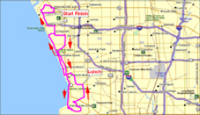
All routes today travel many of the same areas and streets, but they do not stick together. The all split within the first few miles. This medium (without hill) is very similar to the other medium route except that it skips the climb over Turnbull. Instead of starting out by climbing Turnbull (as the other medium does) it circles around Turnbull to rejoin the other medium route on the other side. Together they continue east to Walnut and the edge of Diamond Bar before turning back west. They stop for lunch in Industry (the same location the long riders eventually get to) and then continue back by circling around Turnbull instead of crossing back over it. The profile below may look hilly, but note that the high point is only about 400 feet higher than the lowest location. The route is pretty much flat.
Click here to download a PDF of the route or here for large format PDF.
Download requires Adobe Acrobat version 7 or better (or equivalent program).
CLICK ON “VIEW FULL ROUTE” IN THE UPPER LEFT CORNER TO ACCESS DOWNLOADABLE GPS FILES FOR YOUR GARMIN.